Scientists Find Tsunami 'Shadow' Visible From Space
Posted by Zaib in Earth and Climate
 For the first time, NOAA scientists have demonstrated that tsunamis in the open ocean can change sea surface texture in a way that can be measured by satellite-borne radars. The finding could one day help save lives through improved detection and forecasting of tsunami intensity and direction at the ocean surface.
“We’ve found that roughness of the surface water provides a good measure of the true strength of the tsunami along its entire leading edge. This is the first time that we can see tsunami propagation in this way across the open ocean,” said lead author Oleg Godin of NOAA’s Earth System Research Laboratory and the Cooperative Institute for Research in Environmental Sciences, in Boulder, Colo.
Large tsunamis crossing the open ocean stir up and darken the surface waters along the leading edge of the wave, according to the study. The rougher water forms a long, shadow-like strip parallel to the wave and proportional to the strength of the tsunami. That shadow can be measured by orbiting radars and may one day help scientists improve early warning systems. The research is published online this week in the journal, Natural Hazards and Earth System Sciences.
The new research challenges the traditional belief that tsunamis are too subtle in the open ocean to be seen at the surface. The findings confirm a theory, developed by Godin and published in 2002-05, that tsunamis in the deep ocean can be detected remotely through changes in surface roughness.
In 1994, a tsunami shadow was captured by video from shore moments before the wave struck Hawaii. That observation and earlier written documentation of a shadow that accompanied a deadly tsunami on April 1, 1946, inspired Godin to develop his theory. He tested the theory during the deadly December 26, 2004, Indian Ocean tsunami, the result of the Sumatra-Andaman earthquake.
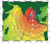
Godin and colleagues analyzed altimeter measurements of the 2004 tsunami from NASA’s Jason-1 satellite. The data revealed clear evidence of an increased surface roughness along the leading edge of the tsunami as it passed across the Indian Ocean between two and six degrees south latitude.
Tsunamis can be detected in several ways. One detection method uses a buoy system that warns coastal communities in the United States of an approaching tsunami. NOAA’s Deep-ocean Assessment and Reporting of Tsunamis (DART) early warning system uses sensors on the ocean floor to measure changes in pressure at each location. The DART network of 39 stations extends around the perimeter of the Pacific Ocean and along the western edge of the North Atlantic Ocean and Gulf of Mexico. The technology provides accurate, real-time information on the amplitude, over time, of an approaching tsunami. NOAA's tsunami warning centers then use this information to forecast the tsunami's impact on coastlines.
A second method uses space-borne altimeters to detect tsunamis by measuring small changes in sea surface height. Only a handful of these instruments are in orbit and the observations are limited to points along a line.
The new study presents a third way to detect tsunamis — by changes in the texture of the surface water across a wide span of the open ocean.
Godin’s research confirmed his theory that a tsunami wave roughens the surface water through air-sea interaction. First the leading edge of the tsunami wave stirs up the surface winds. Those same winds, which become more chaotic than the wave itself, then churn the surface waters along the slope of the wave.
Because rough water is darker than smooth water, a contrast forms between the dark, rough water of the wave and the bright, smooth water on either side of it. Common scientific instruments, called microwave radars and radiometers, are able to detect this contrast, known as a tsunami shadow.
When orbiting the Earth, microwave radars and radiometers can observe a band of ocean surface hundreds of kilometers wide and thousands of kilometers long. If programmed correctly to observe sea surface roughness, they could potentially map an entire tsunami, said Godin.
The paper, “Variations in sea surface roughness induced by the 2004 Sumatra-Andaman tsunami,” by O. A. Godin, V. G. Irisov, R. R. Leben, B. D. Hamlington, and G. A. Wick, appears in Natural Hazards and Earth System Sciences, a journal of the European Geosciences Union.